|
|||||||
|
|||||||||||||
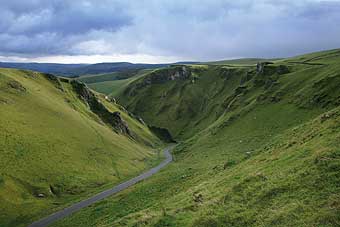
ATCHISON'S WALKS - THE COMPLETE HILLS OF BRITAIN
Volume Two - NORTHERN ENGLAND
This book illustrates the areas included with our new style of front cover, hopefully that will be clearly recognisable as the series develops (Volume 1 with its photos will become a collectors book). The Lake District has been excluded, simply because it deserves a volume of its own - and works well in combination with the Scottish Southern Uplands to make Volume 6.
The Pennines are included in their entirety, from the Peak District up to the natural valley cutting across from Carlisle to Newcastle. The quiet and desolate Northern Pennines offers the highest peak along the backbone of England - Cross Fell. The Howgill Fells fall to the E of the M6 motorway and provide for a far quieter alternative to the Lake District, plus are lower and usually benefit from escaping hill fog (low cloud).
The Yorkshire Dales are covered extensively, with many new walks taking advantage of open access ground. These new trails run along the edges of the escarpments and are often well drained, rather than the summit brows that tend to be convex and poorly drained. Two pretty demanding days are included for the Forest of Bowland - again another area that has opened up with the Open Access Ground agreement. The Central Pennines are covered in detail - with some surprisinly wild and challenging routes. All of the major tops in the Peak District are included, with some challenging days out that will surprise many - not for the faint hearted.
This book also includes the Hills to the East of the Pennines, fully covering the North Yorkshire Moors, and offering a spledid walk in both the Yorkshire Wolds and Linclonshire wolds respectively. This volume is very comprehensive, and offers a mammoth challenge for most.
NORTHERN ENGLAND - YORKSHIRE THREE PEAKS CHALLENGE
This is the finest challenging walk in the book, and is a TIRING day out. It passes over 3 separate summits of Pen-y-ghent, Whernside and Ingleborough; contains 4754 ft of ascent (1449 metres), and is 23.2 miles long (37.2km). The route is a spectacular day out and gets a non stop walking time of 7.58 hours. Expect to take 10 hours with rests.
Hill Running: Mens running time is a minimum of 3.59, and women 4.23.
MAJOR POINTS for anybody who is interested in the book.
- SHORTEST WALK: Dufton Pike in Cumbria - from Dufton, an enjoyable hour and a half circuit from this Pennine village up to a superb viewpoint.
- LONGEST WALK: Around 23 miles as the Yorkshire Three Peaks Challenge
- LOWEST HILL: Normanby Wold near Market Rasen - at just 531 ft.
- HIGHEST HILL: Cross Fell in the Northern Pennines at 2930 ft.
- WETTEST WALK: Longstone Moor in the Peak District, passing at least 10 pubs on the way.
- MOST ARDUOUS ASCENT IN A DAY: Howgill Fells 7 peaks, 4659 in just 6 hours.
- MOST RUGGED DAY: Thack Moor in the Northern Pennines - including 2 hours across wild open moorland.
TOTAL LOGISTICS for anybody who is energetic and wants to complete all of the BIG WALK ROUTES.
- 141,155 ft of ascent (43,024m), more than 4 times the height of Everest from sea level.
- 300 Hours of walking, 871 miles.
- To ascend the 150 most impressive Hills in Northern England.
- The enticement to visit over 100 different pubs on the way.
- The opportunity to visit every one of the hundreds of different spots that the photos were taken for this book.
Northern England - is 288 pages: 210mm high x 116mm wide x 12mm thick (8¼" x 4¾" approx, ½" thick). It is fully sewn bound with a card cover that had fold away flaps for page markers.
NOTE: The binding of our walking-running books is stiched with modern nylon thread. This cord will stretch when you open the book fully, and allows you to bend the book completely back on itself (do not try this with other manufacturers books that may be cotton thread bound). This offers a massive advantage, since all of the double spread spreads will open out flat and stay flat in a map case.
To purchase any of our books, please click on the to buy tab along the top navigation bar of any page. You may find that shops often sell out of stock during the popular walking-running season.
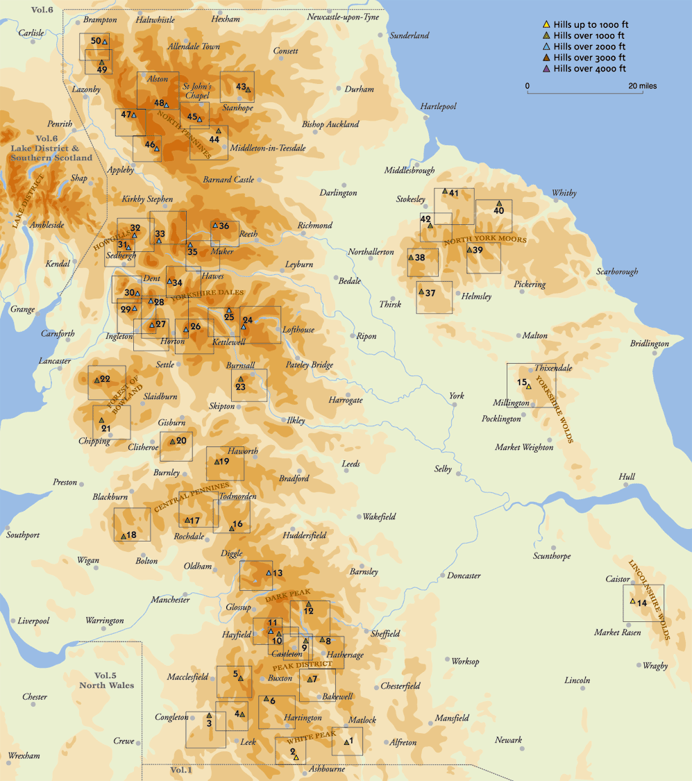
- Winnats Pass (Mam Tor, Peak District)
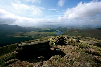
- View towards Hayfield from Kinder (Peaks)
|
||||||||
- View up Grindsbrook (Kinder - Peaks)
|
|||||||
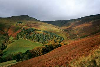
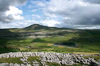
- Ingleborough (Yorkshire Dales)
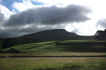
- Pen-y-ghent (Yorkshire Dales)
NORTHERN ENGLAND
Black Rocks Hill Thorpe Cloud The Cloud The Roaches S hining Tor Chrome Hill Longstone Moor High Neb Mam Tor Grindslow Knoll Kinder Low High Stones Black Hill Normanby Wold Garrowby Wold Blackstone Edge Top of Leach Winter Hill Boulsworth Hill Pendle Hill Fair Snape Fell Ward's Stone Cracoe Obelisk Great Whernside Buckden Pike (See below) Pen-y-ghent Ingleborough Whernside Gragareth Great Coum The Calf Randygill Top Wild Boar Fell Great Knoutberry Hill Great Shunner Fell Rogan's Seat Boltby Scar Black Hambleton Rudland Rigg Danby Beacon Roseberry Topping Cringle Moor Bolt's Law Hardberry Hill Fendrith Hill Seamore Fell Cross Fell Burnhope Seat Thack Moor Cold Fell